


 Deutsch
 Nederlands
Übungsklettersteige Stripsenjoch

This 3-part Via Ferrata features a rope bridge and an extremely difficult exit option.
Via ferrata
Length160,0 m
We are sorry, your requested page is not available. You can start a new search on this page!
This 3-part Via Ferrata features a rope bridge and an extremely difficult exit option.
Via ferrata
Length160,0 m

This easy family hike takes you via the Bergdoktorhaus to the Berggasthof Hochschwendt mountain inn.
Wanderstartplatz Tourist Info, Ellmau (800m)
Wanderstartplatz Tourist Info, Ellmau (800m)
Hiking
Easy
2:45 h
8,7 km
270 Elevation gain

31 routes, including 14 multi-pitch.
Route number32
Access time1,5
Sport climbing
 Partially open
By bike through the culinary region Wilder Kaiser.
anywhere along the tour
anywhere along the tour
Cycling
Intermediate
38,3 km
560 Elevation gain

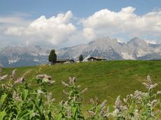
Leisurely high-altitude hike on the mountain and by the Astbergsee lake - the Kaiser's mirror!
Blattlalm, Going (1,246 m)
Blattlalm, Going (1,246 m)
Hiking
Easy
0:40 h
1,7 km
80 Elevation gain
Onto the Hausberg mountain with panoramic views of the Wilder Kaiser and Hartkaiser mountains and back via the Ranhartalm.
Hiking starting point Tourist Info, Ellmau (800 m)
Hiking starting point Tourist Info, Ellmau (800 m)
Hiking
Easy
8:00 h
22,8 km
1020 Elevation gain
 Closed
Peace and strength, slow down and take a deep breath.
Ahornsee car park, Söll (693 m)
Ahornsee car park, Söll (693 m)
Hiking
4:45 h
12,0 km
220 Elevation gain

Themed hiking route with a trail full of natural experiences alongside the refreshing water.
Hiking starting point Tourist Info, Scheffau (738 m)
Hiking starting point Tourist Info, Scheffau (738 m)
Hiking
Intermediate
2:30 h
7,2 km
300 Elevation gain

A scenic circuit past Gieringer Weiher pond, Schwarzsee lake and Going bathing lake.
Tourist Info, Going (764 m)
Tourist Info, Going (764 m)
Cycling
Intermediate
40,1 km
460 Elevation gain
 recommended
Explore small places with farms, forests and views of the valley between Scheffau and Ellmau.
Hiking starting point Tourist Info, Scheffau (737 m)
Hiking starting point Tourist Info, Scheffau (737 m)
Hiking
Easy
2:45 h
8,5 km
270 Elevation gain
 Closed
Enjoy winter silence and an imperial panorama in Söll.
parking area Ahornsee, Söll (693 m)
parking area Ahornsee, Söll (693 m)
Cross-country skiing
Intermediate
5,3 km
80 Elevation gain

The route – stunningly beautiful & challenging
Hiking starting point Tourist Info, Söll (689 m)
Hiking starting point Tourist Info, Söll (689 m)
Jogging
Intermediate
7:30 h
18,0 km
1410 Elevation gain
 Partially open
Gruttenhütte - Kaiser-Hochalm - Steiner-Hochalm - Hinterschießling Alm - Rehbachklamm - Scheffau, Dorf
Gruttenhütte, Ellmau (1,620 m)
Scheffau village (889 m)
Hiking
Intermediate
4:30 h
11,4 km
190 Elevation gain
 Partially open
Two very demanding, fantastic lookout peaks on the Wilder Kaiser, which are not to be underestimated.
Hiking starting point Wegscheid, Scheffau (883 m)
Hiking starting point Wegscheid, Scheffau (883 m)
Hiking
Difficult
9:00 h
11,0 km
1440 Elevation gain

Fork 823/826 – via waterfall – Veitskirche – Steiner-Hochalm
Fork on the Wilder-Kaiser-Steig 823/826 (1,405 m)
Steiner-Hochalm, Scheffau (1,257 m)
Hiking
Intermediate
2:30 h
3,8 km
360 Elevation gain

Leisurely path of reflection to the St. Anna chapel at Lengau
Parkplatz Liftstation Itter (655 m)
Lengauer Kapelle
Hiking
Easy
1:15 h
3,2 km
270 Elevation gain

This tour is rich in variety and includes slabs, water grooves, as well as a strong overhang and a traverse with an undercling passage.
Number of rope lengths5
Access time1,5
Alpine climbing route
Multi-rope length difficulty levels7-
The Pramarunde circuit - a scenically beautiful circuit at all times of the year
Tourist Information Office, Going (766 m)
Tourist Information Office, Going (766 m)
Jogging
Easy
0:30 h
4,4 km
70 Elevation gain

Shady hike with idyllic resting places and views from the Zillertaler Alpen to the Inn valley.
Hiking starting point Alpenschlössl, Söll (762 m)
Hiking starting point Alpenschlössl, Söll (762 m)
Hiking
Easy
3:30 h
9,5 km
480 Elevation gain

Gaudeamushütte – Gamswegl – path 825 – Gruttenhütte
Gaudeamushütte, Going (1,263 m)
Gruttenhütte, Ellmau (1,620 m)
Hiking
Intermediate
1:45 h
3,2 km
480 Elevation gain

Ellmau Tourist Information Office - football pitch - Ellmauer Hof - KaiserBad - Hausbach farms - Ellmau Tourist Information Office
Tourist Information Office, Ellmau (820 m)
Tourist Information Office, Ellmau (820 m)
Cycling
Easy
8,2 km
110 Elevation gain

This is a very well secured sport climbing route in excellent rock conditions.
Number of rope lengths10
Access time2,0
Alpine climbing route
Multi-rope length difficulty levels8+
 Partially open
Explore peaceful forests, flowering alpine meadows, mystical moors, crystal-clear waters and dramatic rock faces on six individual day hikes that fan out from the valley like the points of a star – always with the striking Wilder Kaiser massif in view and just a light daypack on your back.
in einem der vier Kaiserorte Elllmau, Going, Scheffau oder Söll
in einem der vier Kaiserorte Elllmau, Going, Scheffau oder Söll
Hiking
Intermediate
31:45 h
80,6 km
5050 Elevation gain

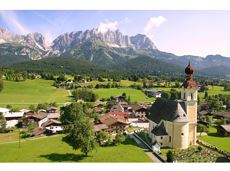
Nice circular hike through Going with visits to numerous chapels.
Hiking starting point Going center (former tourist information Going) (764 m)
Hiking starting point Going center (former tourist information Going) (764 m)
Hiking
Easy
2:45 h
9,3 km
210 Elevation gain
 recommended
Hike along the sunny side along field paths and settlements from Scheffau to Ellmau..
Hiking starting point, Tourismus Info, Scheffau (737 m)
Bus stop Ellmau Bauhof/Dorf, Ellmau (800 m)
Hiking
Easy
1:30 h
5,7 km
100 Elevation gain

Atmospheric winter hike right into the Wilder Kaiser.
Bathing lake, Going (742 m)
Graspoint-Niederalm, Going (981 m)
Hiking
2:30 h
5,7 km
250 Elevation gain

A delightful tour on the sunny side – charming farms and magnificent panoramic views.
Hiking starting point Franzlhof, Söll (703 m)
Hiking starting point Franzlhof, Söll (703 m)
Hiking
Intermediate
3:45 h
11,0 km
420 Elevation gain

A beautiful easy hike at the foot of the Wilder Kaiser
Hiking starting point Tourist Info, Ellmau (800 m)
Hiking starting point Tourist Info, Ellmau (800 m)
Hiking
Easy
1:45 h
5,9 km
60 Elevation gain
 Partially open
Gruttenhütte - Kaiser-Hochalm - Steiner-Hochalm - Jägersteig - Walleralm - Hochegg - Kaindlhütte
Gruttenhütte, Ellmau (1,620 m)
Hintersteiner See, Scheffau (889 m)
Hiking
Intermediate
5:30 h
13,5 km
560 Elevation gain

On the north side up to the Ellmauer Halt summit 2,344 m.
Access time4,5
Via ferrata
Difficulty levelB-C
Via ferrara length2000,0 m
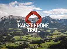
Details about the Kaiserkrone Trail - Trailrunning Event at: www.kaiserkrone.run
Start & Finish - village center of Scheffau (732 m), address: Dorf 45, 6351 Scheffau
Start & Finish - village center of Scheffau (732 m), address: Dorf 45, 6351 Scheffau
Jogging
Difficult
56,0 km
3640 Elevation gain

This stage explores the varied alpine pasture landscape, passing traditional huts, flower-filled meadows and glittering mountain lakes – all the way up to the Hohe Salve, said to be Tyrol’s most beautiful panoramic summit.
Cable car valley station, Söll (725 m)
Brandstadlbahn valley station, Scheffau (682 m)
Hiking
Intermediate
4:45 h
10,5 km
770 Elevation gain

The Anna Grotto is hidden in the middle of a forest at the very foot of the Wilder Kaiser.
Wochenbrunner Alm, Ellmau (1,085 m)
Wochenbrunner Alm, Ellmau (1,085 m)
Hiking
Easy
0:20 h
0,7 km
50 Elevation gain

Intermediate circular hike with breathtaking views on the surrounding mountains. Attention: Trail no 828 is closed due to danger of falling rocks. Detour via path no. 816 and 827 via the Obere Regalm to the Baumgartenköpfl.
Hiking starting point Tannbichl, Going (857 m)
Hiking starting point Tannbichl, Going (857 m)
Hiking
Intermediate
4:45 h
9,8 km
760 Elevation gain

Extended walk through the landscape of Scheffau and Söll
Hiking starting point Tourist Info, Scheffau (738 m)
Hiking starting point Tourist Info, Scheffau (738 m)
Hiking
3:30 h
8,8 km
210 Elevation gain

Enjoy the scenic area of the Hohe Salve where the Söll waters originate.
Exit Keat chairlift, Söll (1,533 m)
Exit Keat chairlift, Söll (1,533 m)
Hiking
Intermediate
3:45 h
10,3 km
530 Elevation gain

Wilder Kaiser hike to a series of special locations. Featuring the natural spectacle of the Schleier Waterfall and a view of the Gaudeamushütte mountain hut.
Hüttling, Going (820 m)
Hüttling, Going (820 m)
Hiking
Intermediate
6:00 h
13,6 km
980 Elevation gain

Along with the Murmeltierfelsen and Gamsfelsen, there are a total of 17 climbing routes of difficulty levels 3 to 6b+ near the Gaudeamushütte mountain hut.
Route number19
Access time1,0
Sport climbing

Enjoy snowy forests and nature in winter.
Hiking starting point Tourist Info, Scheffau (738 m)
Hiking starting point Tourist Info, Scheffau (738 m)
Hiking
1:45 h
3,8 km
170 Elevation gain

Overview of all competition routes of the Trailrunning Event "Kaiserkrone Trail". Details about the event at: www.kaiserkrone.run
Event area - village center of Scheffau (732 m), address: Dorf 45, 6351 Scheffau
Event area - village center of Scheffau (732 m), address: Dorf 45, 6351 Scheffau
Jogging