


 Deutsch


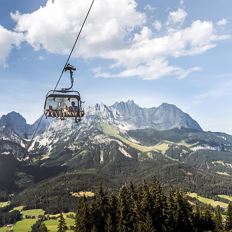
Chair lift Going - Astbergbahn Going
Cosed - Open from 04.06.2026
Going am Wilden Kaiser
(0043) 5358 2442
Read more
The composition of the trail varies between forest road, path, meadow path, forest trail, field path.
Rucksack, sturdy hiking/mountaineering boots with anti-slip treaded soles, weather-appropriate hiking gear (breathable), a change of clothes, sun protection (sunglasses, sun cream, lip protection, headgear), waterproofs (rain jacket/poncho, pocket umbrella, rucksack protector), cold protection (hat, gloves), sufficient food and drink, hiking poles (height adjustable) if required, first aid kit incl. rescue blanket and bivouac sack, mobile phone with fully charged battery, headlamp, plastic bag for waste, hiking map, route description and information materials (GPX track), ID, insurance card, cash
Read more
KaiserJet stop “Going Bergbahn (Astbergbahn)”.
More information at: www.wilderkaiser.info/mobility
Heading from Wörgl or Kufstein on the B178 road, take the first exit on the right after Ellmau – this leads to the Astbergbahn chairlift. Turn left at the end of this road. You will reach the Astbergbahn chairlift after approx. 300 m.
Heading from St. Johann on the B178 road, take the first exit on the left after Going (Hotel Blattlhof) – this leads to the Astbergbahn chairlift. Turn left again at the end of this road. You will reach the Astbergbahn chairlift after approx. 300 m.
Car park Astbergbahn chairlift valley station, Going (805 m) – for free
Read more
Fitness
Technical
Experience
01
Jan
02
Feb
03
Mrz
04
Apr
05
May
06
Jun
07
Jul
08
Aug
09
Sep
10
Oct
11
Nov
12
Dec
Cosed - Open from 04.06.2026
Going am Wilden Kaiser
(0043) 5358 2442
Cosed - Open from 04.06.2026
Going am Wilden Kaiser
(0043) 5358 2713

Cosed - Open from 14.05.2026
Ellmau
(0043) 664 4303590

Cosed - Open from 09.05.2026
Ellmau
(0043) 5358 2320 222
Cosed - Open from 09.05.2026
Ellmau
(0043) 5358 2320

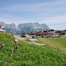
A walk that lets you experience the Brandstadl mountain and leads you to Jochstubnsee lake.
Brandstadlbahn valley station, Scheffau (681 m)
Brandstadlbahn valley station, Scheffau (681 m)
Hiking
Easy
4:45 h
12,7 km
1130 Elevation gain

Enjoy unique panoramic views of the impressive mountains from the Biedringer Platte plateau.
Hiking starting point Tourist Info, Ellmau (800 m)
Hiking starting point Tourist Info, Ellmau (800 m)
Hiking
Easy
4:15 h
12,6 km
470 Elevation gain

Beautiful hike around the Hintersteiner See lake and to a small alpine village.
Hiking starting point Seestüberl, Scheffau (889 m)
Hiking starting point Seestüberl, Scheffau (889 m)
Hiking
Easy
3:45 h
12,3 km
350 Elevation gain

An adventure hike from Ellmau village centre to the Wochenbrunner Alm mountain hut from where you can enjoy stunning views and the Ellmau Stone Circle.
Hiking starting point Tourist Info, Ellmau (800 m)
Hiking starting point Tourist Info, Ellmau (800 m)
Hiking
Easy
4:30 h
13,5 km
530 Elevation gain

A tour of the main filming locations of the TV series “Der Bergdoktor” (The Mountain Doctor) in Ellmau and Going, with a refreshment stop at the inn used during filming
Hiking info point, Tourist Info Ellmau (800 m)
Hiking info point, Tourist Info Ellmau (800 m)
Hiking
Easy
3:15 h
11,4 km
180 Elevation gain

Hiking starting point Tourist Info, Scheffau (737 m)
Hiking starting point Tourist Info, Scheffau (737 m)
Hiking
Easy
3:45 h
11,2 km
410 Elevation gain
2026-04-07
6 °C
2026-04-08
15 °C
2026-04-09
14 °C
2026-04-10
7 °C
