


 Deutsch
 Nederlands
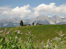
Wilde Gams (Weißbach)
 Open
OpenAccess time0,08333333333333333
Via ferrata
Difficulty levelD-E
Via ferrara length150,0 m
OpenAccess time0,08333333333333333
Via ferrata
Difficulty levelD-E
Via ferrara length150,0 m

It’s up and away to a popular inn in Söll.
Hiking starting point Tourist Info, Söll (689 m)
Stallhäusl, Söll (972 m)
Cycling
Intermediate
6,1 km
310 Elevation gain

The best seat in the house for a view of the Wilder Kaiser!
Hiking starting point Going center (former tourist information Going) (764 m)
Hiking starting point Going center (former tourist information Going) (764 m)
Hiking
Easy
2:15 h
5,8 km
290 Elevation gain

A roundhike with family-picnic in a meadow. Tip: bring a pair of binoculars to see the chamois on the rocks.
Hiking starting point Jägerwirt, Scheffau (883 m)
Hiking starting point Jägerwirt, Scheffau (883 m)
Hiking
Intermediate
2:00 h
5,1 km
350 Elevation gain

Number of rope lengths12
Access time2,0
Alpine climbing route
Multi-rope length difficulty levels6+ (6-/A0)

Gaudeamushütte - Ellmauer Tor - Klammlweg - Gruttenhütte
Gaudeamushütte, Going (1,263 m)
Gruttenhütte, Ellmau (1,620 m)
Hiking
Intermediate
4:45 h
5,9 km
990 Elevation gain

Hikers, young and old alike, will find in this wild romantic gorge natural playgrounds such as bridges and balancing beams by streams and ponds.
Hiking starting point Tourist Info, Scheffau (738 m)
Hiking starting point Tourist Info, Scheffau (738 m)
Hiking
Easy
1:15 h
3,5 km
130 Elevation gain

Varied hike with cosy refreshment stops and a wonderful mountain panorama.
mountain station Salvistabahn / Kleine Salve
Middle station Salvistabahn Itter
Hiking
Intermediate
2:45 h
7,4 km
360 Elevation gain

A walk that lets you experience the Brandstadl mountain and leads you to Jochstubnsee lake.
Brandstadlbahn valley station, Scheffau (681 m)
Brandstadlbahn valley station, Scheffau (681 m)
Hiking
Easy
4:45 h
12,7 km
1130 Elevation gain

Ideal tour for starters and high temperatures.
Hiking starting point Franzlhof, Söll (703 m)
Hiking starting point Franzlhof, Söll (703 m)
Hiking
Easy
0:45 h
2,4 km
50 Elevation gain

Enjoy unspoilt views of the Sölllandl region from snow-covered fields.
Hiking starting point Franzlhof, Söll (703 m)
Hiking starting point Franzlhof, Söll (703 m)
Hiking
2:15 h
5,8 km
100 Elevation gain
 Partially open
Gruttenhütte - Kaiser-Hochalm - Steiner-Hochalm - Jägersteig - Walleralm - Hochegg - Kaindlhütte
Gruttenhütte, Ellmau (1,620 m)
Hintersteiner See, Scheffau (889 m)
Hiking
Intermediate
5:30 h
13,5 km
560 Elevation gain

Going, Hüttling - Schleierwasserfall - Obere Regalm - Baumgartenköpfl (Bergsteigergrab) - Gaudeamushütte
Hiking starting point Hüttling, Going (820 m)
Gaudeamushütte, Going (1,263 m)
Hiking
Intermediate
4:00 h
7,3 km
860 Elevation gain

Winter hiking trail at Brandstadl with magnificent panoramic views
Brandstadlbahn summit station, Scheffau (1,643 m)
Brandstadlbahn summit station, Scheffau (1,643 m)
Hiking
0:45 h
1,9 km
55 Elevation gain

Leisurely hike through forest and across meadows to the sunny plateau of Going and back
Hiking starting point Going center (former tourist information Going) (764 m)
Hiking starting point Going center (former tourist information Going) (764 m)
Hiking
Easy
1:15 h
4,1 km
70 Elevation gain
Onto the Hausberg mountain with panoramic views of the Wilder Kaiser and Hartkaiser mountains and back via the Ranhartalm.
Hiking starting point Tourist Info, Ellmau (800 m)
Hiking starting point Tourist Info, Ellmau (800 m)
Hiking
Easy
8:00 h
22,8 km
1020 Elevation gain

Pleasant circular hiking trail through forests and meadows to the romantically situated moor lake.
Hiking starting point Franzlhof, Söll (703 m)
Hiking starting point Franzlhof, Söll (703 m)
Hiking
Intermediate
2:00 h
5,7 km
240 Elevation gain
 recommended
Walking tour for refreshment and relaxation close to the village.
Hiking starting point Tourist Info, Scheffau (738 m)
Hiking starting point Tourist Info, Scheffau (738 m)
Hiking
Easy
0:45 h
2,3 km
70 Elevation gain
 Partially open
Gruttenhütte - Kaiser-Hochalm - Steiner-Hochalm - Hinterschießling Alm - Rehbachklamm - Scheffau, Dorf
Gruttenhütte, Ellmau (1,620 m)
Scheffau village (889 m)
Hiking
Intermediate
4:30 h
11,4 km
190 Elevation gain
 Closed
Explore the sunny foot of the Pölven mountain.
Cross-country skiing
Easy
0,9 km
 Open
OpenAccess time0,08333333333333333
Via ferrata
Difficulty levelA/B
Via ferrara length180,0 m

The Kaiser Marathon Ultra - 77 km and 3.210 metres of elevation gain. A welcome challenge for our top athletes!
Söll village centre
Hohe Salve mountain
Jogging
Intermediate
77,0 km
3210 Elevation gain

This familyfriendly hike leads you along the panoramic trail from the Brandstadl mountain in Scheffau to the Hartkaiser mountain in Ellmau.
Brandstadlbahn mountain station, Scheffau (1,650 m) or Hartkaiserbahn mountain station, Ellmau (1.550 m)
Brandstadlbahn mountain station, Scheffau (1,650 m) or Hartkaiserbahn mountain station, Ellmau (1.550 m)
Hiking
Easy
1:50 h
6,0 km
170 Elevation gain

The most adventurous route to the highest hut on the Wilder Kaiser.
Wochenbrunner Alm, Ellmau (1,085 m)
Wochenbrunner Alm, Ellmau (1,085 m)
Hiking
Intermediate
3:15 h
5,5 km
550 Elevation gain
 recommended
Explore small places with farms, forests and views of the valley between Scheffau and Ellmau.
Hiking starting point Tourist Info, Scheffau (737 m)
Hiking starting point Tourist Info, Scheffau (737 m)
Hiking
Easy
2:45 h
8,5 km
270 Elevation gain

Fork 823/826 – via waterfall – Veitskirche – Steiner-Hochalm
Fork on the Wilder-Kaiser-Steig 823/826 (1,405 m)
Steiner-Hochalm, Scheffau (1,257 m)
Hiking
Intermediate
2:30 h
3,8 km
360 Elevation gain

Going, Hüttling – Graspoint-Niederalm – Obere Regalm – Brennender Palven – Gaudeamushütte – Klamml – Gruttenhütte
Hiking starting point Hüttling, Going (820 m)
Gaudeamushütte, Going (1,263 m) / Gruttenhütte, Ellmau (1,620 m)
Hiking
Intermediate
4:30 h
8,0 km
1120 Elevation gain

The varied loop takes you on leisurely valley cycle paths as well as a mountain evaluation on the MTB routes 265 and 350 once around the Hohe Salve lookout mountain.
Tourismus Info, Söll
Tour
Cycling
Intermediate
36,5 km
880 Elevation gain

Ideal circuit for beginners to start exercising
Tourist Information Office, Going (766 m)
Tourist Information Office, Going (766 m)
Jogging
Easy
0:20 h
3,1 km
75 Elevation gain

Number of rope lengths3
Access time2,0
Alpine climbing route
Multi-rope length difficulty levels7-

Family-friendly, leisurely circular hike around the Astberg mountain
Astberg mountain station, Going (1.251 m)
Astberg mountain station, Going (1.251 m)
Hiking
Easy
0:30 h
1,5 km
80 Elevation gain
 Closed
Circular walk on a groomed trail with fantastic views of the surrounding mountains. A sunny, entertaining winter walk during the day and a pleasant, short stroll in the fresh winter air in the evening – covered with artificial snow and illuminated daily until 9.30 p.m.
Hiking starting point Tourist Info, Scheffau (738 m)
Hiking starting point Tourist Info, Scheffau (738 m)
Hiking
0:30 h
1,2 km
20 Elevation gain

The Hintere Goinger Halt (2,193 m) is considered to be the easiest summit to reach in the Wilder Kaiser.
Hiking starting point Wochenbrunner Alm, Ellmau (1,085 m)
Hiking starting point Wochenbrunner Alm, Ellmau (1,085 m)
Hiking
Difficult
6:30 h
9,3 km
1090 Elevation gain

Pull on your walking boots and join us on a hike across Tirol! The first stage of the Eagle Walk provides a truly spectacular start to what is set to be an unforgettable journey from east to west. We begin our adventure in the Kaiser Mountains with their craggy grey peaks towering above lush green meadows. Some of the most famous mountains in this part of Tirol include the Maukspitze, Ackerlspitze, Regalpspitze and Törlspitze, all of which are over 2,000 metres high. The hike begins at the Gasthaus Rummlerhof, a guesthouse to the north-west of the centre of St. Johann. Upon arrival at your destination, the Gaudeamushütte, you can raise your glass and to a successful day and sing: "Gaudeamus igitur - Let us be happy!". Alternatively, why not add an extra challenge and take on the 400 vertical metres up to the Gruttenhütte?
Rummlerhof, St.Johann in Tirol
Gaudeamushütte
Hiking
Intermediate
5:00 h
13,0 km
1060 Elevation gain

With the Söller Zehner (1st competition in the Tour de Tirol) the circuit is run three times!
Hiking starting point Tourist Info, Söll (689 m)
Hiking starting point Tourist Info, Söll (689 m)
Jogging
Easy
3,3 km
80 Elevation gain

Moderate hike with a refreshing reward.
Hiking starting point Franzlhof, Söll (703 m)
Seestüberl restaurant, Hintersteiner See, Scheffau (890 m)
Hiking
Intermediate
3:15 h
9,5 km
460 Elevation gain

A beautiful tour up to the Astberg lake via the Hollenauer Kreuz with fantastic views
Astbergbahn valley station, Going (805 m)
Astbergsee, Going (1.251m)
Hiking
Easy
3,0 km
465 Elevation gain

This pleasant circular walk takes you to Söll’s war memorial in a beautiful section of forest.
Hiking starting point Tourist Info, Söll (689 m)
Hiking starting point Tourist Info, Söll (689 m)
Hiking
Easy
0:30 h
2,1 km
10 Elevation gain
 Closed
Cross-country skiing in imperial style with two options: moderately challenging or just for pleasure.
Cross-country skiing
Easy
5,5 km
50 Elevation gain
 recommended
The Sunnseit circuit lives up to its name - this sunny circular hike leads through a varied landscape with fantastic views of Söll, the Wilder Kaiser, the Hohe Salve and the Pölven massif.
Hiking starting point Franzlhof, Söll (703 m)
Hiking starting point Franzlhof, Söll (703 m)
Hiking
Easy
2:15 h
7,3 km
180 Elevation gain